Date of Visit: Several, but most recently in May of 2009 in Great Smoky Mountain National Park
Website: www.nps.gov/appa
Location: From Georgia to Maine! Trail Headquarters is in Harper's Ferry, West Virginia
Entrance Fee: None for the trail itself, although some access is via state parks, national parks or other lands requiring an entrance fee.
Type of Trip: Day Trips/Section Hikes
Park Passport Stamps Available: 1
Review: Stretching 2,175 from North Georgia to the wilds of Maine, the Appalachian Trail works its way up (or down, depending on which direction you want to go) the spine of the Appalachian Mountains; it passes through 14 different states over its length. The Appalachian Trail (AT) is the granddaddy of the long-distance hiking trails in the United States; it was completed in 1937. Hundreds of people attempt to hike it from end-to-end during one season, usually taking 3-4 months to complete the hike. It is a true wilderness trail, marked by white blazes and rarely passing through towns, requiring distance hikers to carry supplies with them or arrange for resupply drops along the way.

White Blaze along the AT
Although I would love to hike the entire distance of the AT, so far I have managed only several miles -- including a few miles in each Great Smoky Mountain National Park and Shenandoah National Park, as well as the approach trail to Springer Mountain from Amicalola State Park in Georgia (which I will focus on in this post).
In January of 2009, I decided to make a trip up to Georgia to hike the approach to the Appalachian Trail. The trouble with the Appalachian Trail is getting there; the southern end -- at Springer Mountain in Georgia -- lies several miles by trail from the nearest parking lot. The Georgia State Park system maintains the Approach Trail as a part of Amicalola State Park (entrance fee $5, there's a Visitor's Center and camping available in developed campgrounds); from the parking lot at the bottom of the park, its 8.5 miles by trail before you even reach the start of the 2,175 mile Appalachian Trail. In his fabulous book A Walk in the Woods, author Bill Bryson (an Iowan!) describes the approach:
The route led down into a wooded valley with a chuckling stream edged with brittle ice, which the path followed for perhaps half a mile before taking us steeply up into denser woods. This was, it quickly became evident, the base of the first big hill, Frosty Mountain, and it was immediately taxing. (From A Walk in the Woods, p. 35)
Bryson wasn't kidding. I was in reasonable shape at the time, carrying only a daypack and hiking in cool weather (it was January) and this was a pretty hard hike. Right from the beginning, you are climbing and climbing in elevation.

Beginning of Approach Trail to AT

Frozen waterfall along the Approach Trail
After about 7 miles by trail, there is a backpacker's shelter -- a three-sided wooden building designed for sleeping. There are literally hundreds of these shelters scattered throughout the AT and are designed for thru-hikers to use on an end-to-end hike. You cannot reserve a shelter; they are strictly first-come, first-served and can fill up during thru-hiking season. When I was there, only a trail maintenance crew was using the shelter to grab a bite to eat. There is also a picnic table, pit toilet, and water source nearby.

Black Mountain Shelter
I was really pooped by the time I got to the Black Mountain shelter, having hiked 7 miles in about 2.5 hours. However, I stopped and had a bite to eat; I was contemplating turning back but the trail maintenance crew urged me to go on ahead to Springer Mountain. I was really glad I did. The next 1.5 miles were pretty easy, except for the final push up Springer Mountain itself.
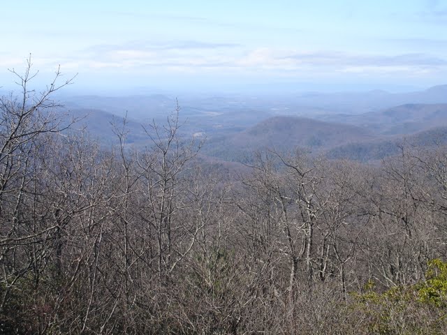
View from Springer Mountain
At the top of Springer Mountain are two plaques, one commemorating the trail itself and one marking the southern terminus of the Appalachian Trail at Springer Mountain.


After a few pictures from the top of Springer Mountain, I decided to head back. The hike back was just as tough as the hike in, although I did have the added benefit of ending on a mile-long downhill slope back to the parking lot. The Visitor's Center was closing just as I reached the parking lot around 5 pm, and I was extremely tired, having hiked 17 miles in one day. Unfortunately, I found a flat tire on my car when I returned! Luckily, a Georgia State Parks ranger saw how tired I was and helped me put on the spare.
All in all, I'm glad I hiked up to Springer and I hope to complete more sections of the AT over the next several years. However, I think this is better done as an overnight hike, maybe including a stay at the Len Foote Hike Inn, a mountain lodge only accessible by foot. 17 miles is far to hike in one day when your legs aren't used to it!
For more information:
Amicalola Falls State Park
National Park Service Page -- Appalachian Trail
Appalachian Trail Conservatory
No comments:
Post a Comment